How the World’s Largest Dam Is Reshaping Asia’s Geopolitical Landscape Beyond Just an Energy Source
Introduction
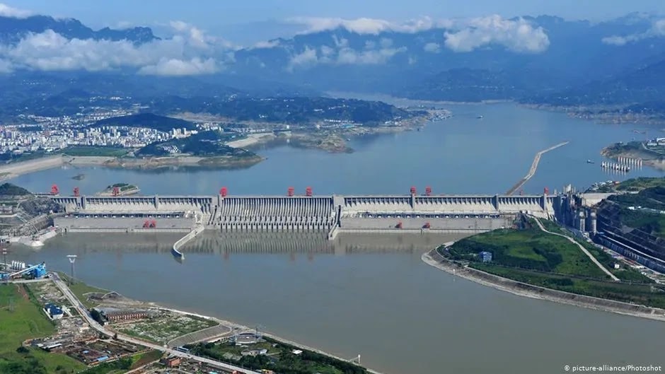
The Medog (Motuo) Hydropower Station is not merely an infrastructure project. It represents a paradigm-shifting mega-development at the intersection of global energy transition, Asian geopolitics, and extreme environmental risks. Regarded as China’s most ambitious engineering feat since the Three Gorges Dam, its strategic implications are far deeper and more complex than any previous project.
This report argues that while the Medog Dam is publicly promoted under the banner of “clean energy,” at its core it functions as a powerful tool for state control. Situated on a transboundary river adjacent to the disputed border with strategic competitor India, and perched atop a cascade dam system spanning the entire river, it wields enormous geopolitical influence. The project’s massive scale and the site’s extreme geological and ecological vulnerability generate risks far beyond its immediate vicinity, threatening regional stability and the livelihoods of over 130 million people downstream.
The analysis is divided into five parts. First, it reviews the technical and engineering specifications of the project, followed by an examination of China’s strategic calculations behind the dam’s construction. Next, it assesses impacts on downstream countries India and Bangladesh, then contrasts Medog with the Three Gorges Dam to highlight why Medog presents a new level of risk. Finally, it concludes with strategic recommendations for downstream nations.
Part 1: Project Dissection and Engineering Ambition
1.1. Technical Specifications and Project Overview
The Medog project is the world’s largest and most expensive hydropower station, overwhelming in scale.
- Installed Capacity: Planned at 60,000 MW (60 GW), nearly triple the Three Gorges Dam’s 22,500 MW.
- Annual Generation: Expected to produce 300 billion kWh (300 TWh) annually, three times the output of Three Gorges and roughly equal to the entire UK’s annual electricity consumption.
- Project Cost: Estimated investment exceeds 1 trillion yuan, or approximately $137–168 billion USD, over four times the official cost of Three Gorges (~$32 billion).
- Construction Timeline: Officially approved in December 2024, with groundbreaking on July 19, 2025. The project will be built in a single phase, with commercial operation slated for 2033.
- Corporate Structure: Managed by the newly established state-owned China Yajiang Group, with ownership and development by PowerChina. This integrated state enterprise structure signals strong central government control and prioritization.
1.2. Blueprint: Geographic and Engineering Design
The project’s location and design are uniquely challenging.
- Geographic Location: The dam is located in Medog (Motuo) County, Nyingchi Prefecture, Tibet Autonomous Region. Its defining feature is its position at the “Great Bend” of the Yarlung Tsangpo River, where the river makes a horseshoe-shaped sharp turn just before flowing into India, with a steep drop in elevation. Open-source analysis confirms the groundbreaking ceremony took place upstream at Mainling, Nyingchi City.
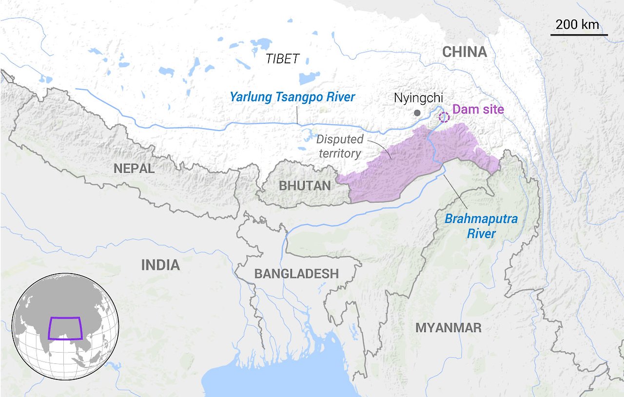
- Engineering Concept: The design is unprecedented. Rather than a traditional reservoir dam, it is a massive run-of-the-river power plant. It will exploit a staggering 2,000-meter hydraulic head over a 50 km stretch of the world’s deepest Yarlung Tsangpo Grand Canyon. This is achieved by tunneling four 20 km long tunnels through Namcha Barwa Mountain to divert river flow and generate enormous hydraulic pressure.
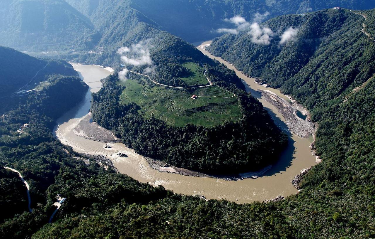
The project’s enormous power potential stems from the unique terrain of the Great Bend, but this same geographic feature is its greatest risk factor. The 2,000-meter drop results from the collision of the Indian and Eurasian tectonic plates. The very geographic characteristic that makes the dam so powerful is also the source of its greatest geological hazards: earthquakes and landslides. This is not a random risk but a fundamental paradox embedded in the project’s design.
Table 1: Medog Hydropower Station – Key Specifications
| Parameter | Value | Source |
|---|---|---|
| Installed Capacity | 60 GW | |
| Annual Generation | 300 TWh | |
| Estimated Cost (USD) | $137–168 billion | |
| Dam/Plant Type | Gravity dam / Run-of-river | |
| Core Engineering Features | 2,000m head, 4 tunnels | |
| Commercial Operation | 2033 |
Part 2: Strategic Calculations: China’s Control of Asia’s “Water Tower”
2.1. Domestic Drivers and Strategic Necessity
China’s motivations for building the Medog Dam are multifaceted.
Advertisement
- Green Energy Narrative: Officially, the dam is framed as a key project to achieve President Xi Jinping’s 2060 carbon neutrality goal, supplying massive renewable energy to replace coal.
- Geopolitical and Security Narrative: Beyond energy, the dam is central to Beijing’s strategy to develop Tibet, consolidate control over the disputed border with India, and strengthen border security. Such mega infrastructure projects serve as a form of hard power projection, reinforcing de facto control over sensitive territories.
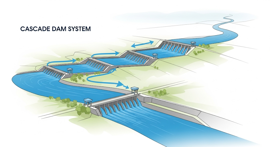
2.2. The Yarlung Tsangpo Cascade System: A Control Network
The Medog Dam must be understood as part of a larger system.
- Cascade Dam Concept: A cascade system involves constructing a series of dams along a river so that the outflow from upstream plants feeds downstream plants. This allows repeated use of water for power generation and integrated control over river flow and energy production.
- Yarlung Tsangpo Cascade: Medog is not an isolated project but the “crown jewel” and final component of an extensive upstream infrastructure network. China already operates several dams on the Yarlung Tsangpo (Zhangmu, Zacha, Jiacha, etc.) and plans more. The Medog project itself will consist of five cascade hydropower stations.
2.3. The Politics of Water and the Mekong Precedent
The theory of “water weaponization” can be concretely analyzed through the Mekong River case.
- “Water Weaponization” Theory: Countries controlling upstream transboundary rivers can restrict flow during dry seasons and release excess water during wet seasons to impose hydrological stress on downstream states, using water as a powerful bargaining chip in diplomatic or military conflicts.
- Mekong Dam Monitor Evidence: The Stimson Center’s Mekong Dam Monitor provides empirical evidence. Analysis shows China’s 12 upstream Mekong (Lancang) dams store significant wet-season flow, exacerbating drought downstream. In 2019, despite adequate rainfall, dams blocked nearly all upstream Mekong flow, contributing to the worst droughts in Thailand, Cambodia, and Vietnam. This pattern offers a reliable model for potential impacts on the Brahmaputra.
Beyond simple water retention or release, cascade systems provide far more sophisticated control. They transform the river from a natural system into a centrally planned utility. China is not merely installing “gates” but building a complex exchange hub that allows precise, strategic regulation of river flow, conferring far greater geopolitical leverage than a single dam. Simultaneously, the “green energy” narrative acts as a geopolitical shield, packaging the project as part of global climate commitments to deflect international criticism and complicate diplomatic responses.
Part 3: Downstream Realities: Perspectives from India and Bangladesh
3.1. India’s Strategic Dilemma: “Water Bombs” and Economic Disruption
- “Water Bomb” Threat: Indian officials, especially the Arunachal Pradesh Chief Minister, have expressed fears that the dam could be used as a “water bomb,” releasing sudden, massive floods downstream during conflicts. There is also risk of dam failure due to earthquakes or landslides.
- Manipulated Droughts and Agricultural Impact: Conversely, water retention could cause severe droughts during dry seasons, threatening the livelihoods of approximately 130 million people and 6 million hectares of farmland dependent on the Brahmaputra.
- Ecosystem Disruption: A key concern is the blocking of sediment flow. The Great Bend region generates much of the Brahmaputra’s sediment, essential for soil fertility across the Assam plains and the entire Northeast.
- Divergent Internal Views: Within India, perspectives vary. Arunachal Pradesh views the dam as an existential threat, while Assam’s Chief Minister suggests reduced flow might alleviate chronic flooding. This divergence complicates a unified national response.
3.2. Bangladesh’s Existential Vulnerability
- Extreme Dependence: As the most downstream country, Bangladesh is highly vulnerable. The Jamuna River (Brahmaputra) is vital to over 160 million people, supporting 55% of irrigation demand, drinking water, and a massive fishery.
- Delta Subsidence: The most serious long-term threat is sediment depletion. The Ganges-Brahmaputra delta relies on natural sediment deposition to counter sea-level rise. Blocking sediment upstream threatens the very existence of this low-lying delta, home to millions.
- Worsened Floods and Droughts: Altered flow patterns could exacerbate both monsoon floods and dry-season water shortages in a country already facing severe water stress and climate change challenges.
Table 2: Brahmaputra/Jamuna River Dependence
| Country | Key Indicator | Value/Statistic |
|---|---|---|
| India | Population Dependent | Approx. 130 million |
| Irrigated Land | 6 million hectares | |
| Major Economic Activities | Agriculture, Fisheries, Hydropower | |
| Bangladesh | Population Dependent | Over 160 million |
| Irrigation Dependence | 55% of national irrigation demand | |
| Water Resource Dependence | Majority of renewable water resources |
3.3. Counterarguments and Downstream Responses
China claims the project lies entirely within its sovereign territory and will not negatively impact downstream regions. It also argues that as a run-of-the-river project, it lacks large reservoirs to weaponize water. However, this contradicts the Mekong precedent.
In response, India is actively monitoring the project and has proposed constructing an 11,000 MW counter-dam in Arunachal Pradesh to offset impacts. It also continues to demand transparency and data sharing through diplomatic channels. China’s strategy imposes a “dam dilemma” on India: to counter the threat, India must invest heavily and overcome domestic opposition to build its own mega-dams.
Part 4: Two Mega-Dams Compared: Medog vs. Three Gorges
A direct comparison reveals that Medog is not simply a larger version of Three Gorges but a fundamentally different and riskier endeavor.
Table 3: Comparative Analysis – Medog vs. Three Gorges Dam
| Feature | Three Gorges Dam | Medog Hydropower Station |
|---|---|---|
| River System | Yangtze (domestic river) | Yarlung Tsangpo-Brahmaputra (international river) |
| Geopolitical Context | Domestic energy/flood control | Transboundary, adjacent to disputed border |
| Installed Capacity | 22.5 GW | 60 GW |
| Official Cost (USD) | ~$32 billion | $137–168 billion |
| Population Displaced | ~1.4 million (realized) | ? More than that |
| Major Geological Risks | Reservoir-induced seismicity and landslides on stable crust | Plate boundary, extreme seismic and landslide risk |
| Major Ecological Risks | Downstream sediment and flow alteration | Fragile Himalayan ecosystem and critical downstream delta |
4.2. Lessons Not Learned from the Yangtze
The severe consequences of the Three Gorges Dam illustrate the risks of mega-dams. Over 1.3 million people were displaced, social unrest ensued, reservoir-induced earthquakes and landslides increased, and irreversible ecological damage such as the extinction of the Baiji dolphin occurred.
Advertisement
4.3. Why Medog Is a Riskier Gamble
Known issues with Three Gorges could be catastrophically amplified at Medog.
- Risk Amplifier 1: Extreme Geology: The Medog site is criticized as “building on tofu,” located at the direct collision point of tectonic plates in the world’s deepest canyon. Geological risks are on a whole different level than Three Gorges.
- Risk Amplifier 2: Transboundary Conflict: Catastrophic failure would not be China’s alone but an international disaster, sending walls of water and debris into India and Bangladesh.
- Risk Amplifier 3: Heightened Geopolitical Competition: Unlike Three Gorges, Medog is being built amid escalating US-China tensions and border conflicts with India, making the threat of “water weaponization” more real and increasing the risk of miscalculation.
From Beijing’s perspective, Three Gorges is considered a success. This “success” may have led planners to underestimate known risks and embark on the far more ambitious and hazardous Medog project.
Part 5: Conclusions and Strategic Recommendations
5.1. Holistic Risk Assessment
The project’s risks multiply rather than simply add up. Extreme engineering complexity, severe geological instability, and intense geopolitical rivalry combine. Failure in one domain could trigger catastrophic failures in others. Experts question not only whether China should build this dam but whether it can be built safely in such an environment. The Chinese government’s lack of transparency regarding detailed environmental and engineering plans fuels skepticism.
5.2. Path Forward for Downstream Countries
Practical policy recommendations for India, Bangladesh, and the international community include:
- Recommendation 1: Establish a “Brahmaputra Dam Monitor”: Modeled on the Stimson Center’s Mekong Dam Monitor, downstream countries should collaborate to operate an independent monitoring platform using satellite imagery and remote sensing. This would provide an independent evidence base to counter China’s data opacity.
- Recommendation 2: Strengthen Legal and Diplomatic Frameworks: India and Bangladesh should intensify efforts to negotiate a legally binding tripartite water-sharing treaty and continuously urge China to accede to the 1997 UN Watercourses Convention on equitable use and dispute resolution.
- Recommendation 3: Invest in Resilient Domestic Infrastructure: Given the low likelihood of China halting the project, downstream countries must invest in mitigation, including counter-dams, improved flood management, drought-resistant agriculture, and delta ecosystem protection and restoration.
- Recommendation 4: Form a Downstream Coastal States Alliance: India should collaborate with Bhutan, Bangladesh, and other downstream neighbors to develop joint protocols for flood early warning and disaster preparedness, presenting a unified front in negotiations with China.
Sources
World’s Largest Hydropower Dam Begins Construction
Advertisement
Satellite Photos Show Where China Is Building World’s Biggest …
Not immediately worried: Himanta on China’s Medog Dam construction
China Authorizes Controversial Hydropower Project in Landslide …
China’s Brahmaputra Gambit: A strategic assessment of Motuo dam | India Sentinels
Building the largest dam on Brahmaputra river’s Great Bend in China | Climate Conflicts
India’s Water Security Strong Despite China’s Brahmaputra Dam - IndiaWest Journal News
China’s Mega Dam on Brahmaputra: Implications for India-China Relations - Vision IAS
China’s Gigantic Hydropower Dam in Tibet: Green Energy or the “Weaponization” Of Water?
Advertisement
Modeling of Cascade Dams and Reservoirs Operation for Hydropower Energy Generation - HENRY
China’s mega dam on Brahmaputra & concerns in India | Explained …
The Mekong Dam Monitor Tracks a River Under Pressure | New Security Beat
The Mekong Dam Monitor Tracks a River Under Pressure - Circle of Blue
New Evidence: How China Turned Off the Tap on the Mekong River - Stimson Center
Country profile – Bangladesh - FAO Knowledge Repository
Advertisement
Water Resource Competition in the Brahmaputra River Basin: - CNA.org.
Dam on upper reaches Brahmaputra will not impact India, Bangladesh: China - The Hindu
China To Build The World’s Largest Hydroelectric Dam On The Yarlung Tsangpo River - PPI
Three Gorges Dam | Facts, Construction, Benefits, & Problems …